Edmund Devine
What exactly is it that I do here? It is a simple question, but at the same time, it is a rather difficult question to answer. Given the situation it is best to start at the beginning, my name is Edmund Francis Devine, I am twenty-three years of age and an avid student of History. Since I was a young boy in elementary school, I’ve been fascinated by the study of History and of the human race. As I grew up my big dream was to be a Historian, to study mankind and bring it out to the public population. As such when I became a Freemason I was introduced to FREA by Michelle Snyder during her presentation on the ancient history of tattoos in general and the ‘Rx’ symbol in particular. Since that day I’ve been here at FREA, working in the archives historical section and enveloping myself in the endless papers and books that make up Dr. Enzmanns life work. The major reason I enjoy staying here at FREA is the work matters, it is enough to change how I view the world, how I view society, culture, nations, and the ancestral history of our modern world. It is something that is so revolutionary it is not surprising that most of society does not know about the work. It challenges the very foundation of modern ‘social sciences’ and changes actively how you have to view the world, that is why I stay.
Working at FREA presents its challenges, and where to start is a good example of these problems. It sounds so simple; you start at the beginning! But the beginning of Dr. Enzmanns work is very close to the beginning of the formation of the earth into a livable atmosphere and ends with the wide colonization of space. The present work I am undertaking is a great timeline, one for which I have had to arbitrarily set the start date at 1,000,000 B.C. and end it at 2042 A.D. Within this timeline I touch upon the climatological work Dr. Enzmann did, as it pertains to the migration and settlement of humans, cultural history, linguistic, and mythological/symbological history of humanity. Beyond that, a lot of my job involves reading and studying, as much as it is writing and publishing Dr. Enzmanns work. At present the current reading list includes The Histories: by Herodotus, and Maps of the Ancient Sea Kings: by Charles H. Hapgood. The latter I shall be writing in the future about, in particular, a particularly puzzling map called the ‘Piri Reis’ map, an Ottoman map drawn about 1513 A.D. This map is intriguing because if holds information that it shouldn’t, including a rather accurate depiction of Queen Maud Land in the Antarctic, but it is not simply a map of the ice-covered world of Antarctica that we know of, but instead it is a rather accurate depiction of the land when the ice was not there, something that hasn’t been true of that region for over ten-thousand years. This shows that either that particular Ottoman could see through miles of ice, or and more likely, the map he made used maps that had used maps that were made by men and women who could see the polar caps when there was no ice. I hope that over the next few publications, you will enjoy the research and find it as interesting as I do.
Below you shall now see a single entry, 5,060 BC in the timeline I am working on. It is still a rough draft and various parts of it are still subject to edit, but it shall give a glimpse of how in-depth the work of Dr. Enzmann is and how deep the work that we are struggling the publish is.
5,060 BC Excerpt: Masonry’s Pillars Index Printed, pg. 68, Atlantic II to pg. 74
Warm 5,060-4,740 BC, Zodiac Month of Great Year Taurus 4,320 to 2,160 BC
Germany’s Goseck, farmer’s observatory.
Pillars c.4,500 BC
(Note) Writings about Europe’s first farmers can be contended by historians, editors, religions, and a variety of interests grinding political axes. The excellent article does not say: “Farming was invented in the Middle East, essentially Palestine, Syria, and perhaps to an extent in Anatolia.” However, an indoctrinated reader or even student can read it that way.
Evidenced on Sites
(note) Development of Farming seeming utterly independent of and earlier than anything in the above-noted Middle East is briefly tabulated below.
c.18,000 BC Solutrean indications of Iberian and Southern France hazelnut sylviculture.
c.14,500 BC Lascaux acorn, hazelnut, grass-seed grain gathering & sylviculture.
c.12,500 BC Bølling Rhone-Rhine-Danube Hamburgian culture: wool textile weaving on upright weighted looms, soap making from soapwort ash and fats, written (cardinal, lead-line, link-line, secondary cardinal, script) language, hazelnut and grass seed breads
- 9500 BC Allerød shoe-last plows used to cultivate pocket gardens and small kitchen gardens
- 8500 BC Pre Boreal animal-drawn plows used along river terraces of the Danube about Iron Gate
(note) This is five thousand years before the plow was allegedly invented in the Middle East by Semites (ancestral Arabs and Hebrews) who brought agricultural knowledge of herding, duck & goose flocks, and grain-growing, to Europe’s Rhone-Rhine-Danube waterways c. 6500 BC, then the plow c. 3750 BC.
- 7500-c. 6000 BC, Boreal Val Camonica farming and animal-drawn plows, Maglemosian & Tardenoisian kitchen gardens, Southern Europe Impressed-Ware Pottery, Brittany, Ireland, England North Sea & Baltic observatories.
- 5800-c. 5300 Atlantic Rhine Danube early LBK pottery, slip casting, which thousands of years later will be used to make Epinetron, farmers, herders of: sheep, cattle, goats, and horses, and duck & goose flocks
- 5500-c. 5000 Atlantic LBK, at this time, conceive the Goseck agricultural observatory which will be fully operational c. 4500 BC.
(Note) We believe that the megalith yard is standardized here and that with this the Proto Indo Proto-Indo-European language is spread.
- 4500 BC Atlantic Central European and Carpathian Basin Rössen culture – copper metallurgy. C. 4000 BC Proto Hittites seem to have been located just west of the Pripet Swamps of Poland and Belorussia, and from c. 4000 to c. 3500 BC preparing some iron from bog ores.
(note) anomalous iron metallurgy appeared as early as c.5,000 BC in the LBK culture. It was used occasionally and only for ornaments. The metallurgy seems to have developed from using blow pipes such as reeds, to cause peat to burn faster and hotter. All peat contains Limonites and Goethites precipitated by bacteria. In burning peat, tiny beads of iron will smelt out. With some skill, blobs can be brought together. Proto Hittites migrate to regions in today’s Ukraine, north of the Black Sea c. 3750-c. 2900 BC. From there, they go to Anatolia (Asia Minor) founding the Hittite Nation, and quickly learn to smelt iron from magnetite ores, rather than more difficult to smelt iron hydroxide modules raked out of peat bogs.
(note) Conventionally as outlined by Nigel Calder:
- C. 4000 BC ancestral Hebrews and Arabs, who are almost universally allergic to dairy products, invent plows, dairying, butter, cream, and cheese which soon spread throughout northern and central Africa, where only among immigrants from Europe does lactose tolerance exist after babyhood.
- 3800-3200 BC, ancestral Hebrews and Arabs fleeing the drought-haggard, overpopulated Arabian Peninsula, and at war with Mesopotamian nations, the Iranian Plateau’s populations, Egypt, and Assur Plateau, migrated to Europe, teaching the inhabitants plowing, herding, and weaving.
(note) All this when foul weather has caused an agricultural catastrophe in the Balkans, Pontic Regions, and from Iberia through Northern Europe and along the Rhone-Rhine-Danube waterways.]
(note) A trace of Semitic DNA through the Balkans is treated as powerful evidence of such a migration of knowledgeable agriculturalists.
(note) At the same time, entire European DNA dominant areas of North Africa and the Middle East are totally ignored. Many hold it likely that dairying was invented in Europe and brought southward, the reverse of convention.
- 2500 BC, African dairy herders, who would be Bantu Nations, moved southward with the Bantu expansion. It’s indicated that about this time Afro-Asiatics taught Proto Celts, perhaps the earliest Hallstatt Celts, dairying.
C.1800 BC Hebrews invent phonetic writing which is spread by Phoenicia then Carthage. Completely ignoring probable phonetic scripts of c. 4500 BC as on the Tărtăria Tablet (shown). Franco-Cantabrian phonetic signs, probable phonetics early as the Bölling c.12,500 BC cardinal-lead line-link line script including a few phonetic symbols; and it’s worth mentioning Leroi-Gourhan’s comment: “At Lascaux (c.14,500 BC) I really believe they had come very close to an alphabet.”
- 1000 BC-170 Cypriots, Jews in Cyprus, invented and industrialized iron metallurgy, an art rapidly adopted by Europe’s Celts and Africa’s Bantus. Completely ignoring the Carthaginian c. 1200-800 BC Mediterranean tin blockade which was broken by Hallstatt Celtic iron weapons, which abruptly started the iron age.
- 5060-4740 BC Atlantic II, Omphalos as Prime Meridian.
(note) We consider that it has variously and somewhat guardedly been written that nigh onto two thousand years of exterior force blockading Europe, isolating it in the south from the Black Sea, across the Mediterranean to the Atlantic, and in the east at Sari (Tsaritsyn, Stalingrad, Today’s Volgograd), and an interior force – deconstructive malfeasance paraded as religion – created a nearly totally black era; black with ignorance, which is “not knowing,” not “stupidity”.
- 1,650-600 BC, a Greek Dark Age destroyed literacy, and along with a Mediterranean Blockade, destroyed much, but not all European knowledge of geography and navigation.
During a 2000 year European Dark Age separate knowledge of history, astronomy, geography, and navigation developed from c.6000-2800 BC. The European Age of Enlightenment endured from c.1500 to 1950. Currently, worldwide European populations are suicidality inclined toward creating another Dark Age. However, this will likely fail, as the Han Chinese, Indian Peninsula, and Semitic populations are not so inclined.
We now consider astronomical sciences developed between c.6,000 BC, or likely much earlier, and c.2800 BC. Here 6000 BC marks the beginning of the Atlantic Centuries of the Grand Warm Climate Optimum, and 2,800 BC is when wars for control of the Mediterranean commenced. Latitude is well understood by c.5,060 BC, while Longitude is known but difficult to measure.
5,060 BC Atlantic –II- Written Phonetics –Old European Vinca -1- ceramics, wire bracelets, copper sickles, copper cold-working, copper-annealing, copper casting. Phonetic writing. 4,740 BC Atlantic –III- –Old European Vinca -2- 4,000 BC Atlantic –IV- –Old European Vinca -3-.
Observation Some comets reappear at regular intervals, some comets impact the Earth
Observation often meteor swarms not only create glowing-radiant streaks but come all the way down to earth where pieces can be collected.
Questions Can meteor falls be predicted. Can comet reappearances be predicted? Can comet impacts be predicted
Answers Meteor falls can be predicted; however they extend over hours and even days, therefore they mark calendric seasons but cannot be used by navigators. Comet reappearances and even impacts can be predicted.
Meteorites & Tektites
Tushpa (Tuspa) site near Lake Van, Turkey (Armenia) c.1000 BC capital of Ururat Kingdom.
From Tula, c.700 BC Toltec Site, Mexico. C.200 BC Aztec Tollan, a confluence or city of many neighborhoods. The image is breaded, the features are Celtic. The Object on a pole suggests a meteorite or annual meteor shower. The pole represents the Zodiac’s annual sequence.
Sinai Peninsula calendric tablet below, with a cone on top suggesting a meteorite, or we think less likely a recurrent comet.
(note) Early as 3000 BC iron meteorites were collected in Egypt. Occasionally knives were made of them. Nickel iron meteorites are the only known natural source of metallic iron. Palm trees generously collect relatively large and surprisingly long-lasting pools of water. Giraffes will drink there, and these long-lasting “pools” are additionally notorious mosquito hatcheries, which have much to do with malarial plagues. The lower figures represent the warm season divided into two parts, and the cooler season divided into two parts. The pillar represents a year-long zodiacal sequence.
Egypt’s Celestial Ben Ben Boat in which Ra arrives on Earth from the heavens. We suggest it originates from sightings of meteorites.
Syria Celestial Angel arrives above Earth in a vehicle we suggest originates from observation of meteorites. Dura-Europos site, close to Mari on Euphrates River, Syria, a synagogue from c. 300 BC-256 AD destroyed by Sassanians. The images are wall paintings. The pillars are classical representations of Solomon’s Temple. The arc is above a sacred place where the Torah is kept. Was Abraham inspired by a fireball?
The Piri Reis Map was discovered in 1929 AD. Turkish Peri Bin Haji Memmed compiled 1513 AD, he claimed from maps used by Alexander the Great and even far earlier sources. Dr Enzmann suggests 4,500 BC and earlier Queen Maud and other parts of the Antarctic were ice-free.
Question How and why do you convolute Masonry’s symbolism associated with Israel’s Prophet Amos with triple-tau, date it to c. 4800 BC then associate this with God’s illustration of ethics to Prophet Amos with a plumb-line?
Comment: Remember God’s warnings, God’s advice, and God’s ethical discussions with Prophet Amos are accompanied by easily understood examples and similes. Remember, God speaks with a simple shepherd working in the wilderness and demonstrates with a plumb line.
Question So, why do you carry this back to Atlantic II centuries c. 4800 BC and bring in triple tau?
Observation seasons and activities repeat year after year.
Question can we count and predict them?
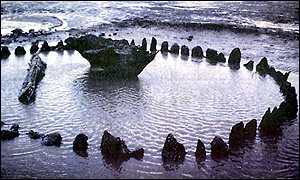
Stonehenge c. 8200 BC east-west & again c. 7150 BC east-west, 3100 BC 56 pillars, 2600 BC briefly abandoned, 2000 BC bluestones
RDE: It was selected as the British site from which a worldwide primary east-west latitude is extended. It precedes Germany’s Goseck site. It may be the origin of Europe’s Salt Lines.
- 4000 BC and earlier Brittany has Venus Mariner’s observatories in operation.
RDE The Goseck farmer’s observatory
RDE each observatory served as its own omphalos, the equivalent of today’s Greenwich Primary Longitude Line as the prime meridian
RDE much ink has been spilled accusing Jews, Christians, Muslims, along with sea voyaging Phoenicians and Carthaginians of all manner of arrogance proclaiming Jerusalem’s Mount Moriah’s Rock the ‘center of the universe’. In all likelihood, the rock was simply set as the prime meridian, which is perfectly reasonable.
- 4000 BC Newgrange. Venus Mariners’ observatories were started well before 4000 BC. Long experience and experimentation testify to its (Newgrange) brilliantly-engineered and precision-constructed up-slope passage and undulating corridor – an astonishingly effective light trap for eliminating early morning sky glow while at the same time admitting Venus’s light brilliantly.
- 4000 BC Bryn Celli Ddu Gawres (Hill of the Black Grove) Venus Mariners’ Observatory was started well before 4000 BC. By 3200 BC it was operational, serving as a precision clock with which mariners can measure longitude
RDE knowledge of distance north and south of a primary east-west latitude has been widely known for millennia: Newgrange, Knowth, Skara Brae, Orkney’s Pierowall, 5000 BC Serbia’s Vrsac site, c. 4200- c. 2200 Indo Aryan sites in the Altai, Tien Shan, and Nan Shan regions.
RDE I have previously suggested that the worldwide standard megalith yard seems to have originated at c. 4500 BC or earlier at Goseck Observatory and was a factor in spreading Indo-European languages. I now suggest that knowledge of a primary east-west latitude is even earlier, and similarly expanded Indo-European languages”
Now, in this snippet, you may see that some of the dates are earlier or later than 5060 BC. It is to be expected, as Dr. Enzmann’s primary work is the intersection of all human knowledge, and as such, it cross-references itself repeatedly and as such, it warrants that we mention both at that date entry and also here where it is referenced we mention it.
In closing, I hope that you will enjoy this trip as much as I will, and will continue to support FREA as it is a non-profit truly worth people’s investment, without it we will sorely fail our forebearers to maintain that torch of knowledge, to continue our people’s ancestral lore. Without it, a light will go out, most likely forever, unless we publish and get this information out to the public. Thank you.